

PROVIDING DRONE SERVICES TO THE ARBORICULTURE INDUSTRY
Drones in Arboriculture
Providing a range of Commercial Drone Services for Arboriculture and Ecology across Derby, Nottingham, the Midlands, and UK, using cutting-edge drone technology. We are fully insured and certified by the Civil Aviation Authority (CAA).
EXPERIENCED PILOTS
TRUSTED BY BIG NAMES
CAA CERTIFIED
INSURED DRONE SERVICES
Experienced Drone Pilots helping Arboriculture
Drones are quickly becoming the technology of choice for arboriculture and ecology for use in aerial tree inspections, identifying and monitoring pests and disease, ecological habitat mapping, topographic surveys, archaeological aerial reconnaissance, and high-quality photography.
Our team of experienced drone pilots are dedicated to delivering high-quality results to our clients.
Using drones in arboriculture and ecology allows us to take tree surveys and inspections to new heights, delivering comprehensive insights from above Nottingham, Derbyshire, East and West Midlands, London, and the UK.

Expect professionalism, reliability, and excellence - these are the fundamental values at the core of everything we do.
Civil Aviation Authority (CAA) A2 CofC (Certificate of Competency) and GVC.
£5,000,000 EC 785/2004 compliant Public Liability Insurance.
Experience working on a range of projects with extensive experience on active construction sites.
Construction Skills Certification Scheme (CSCS) adhering to Health and Safety regulations.

Our arboricultural drone services
We regard ourselves as innovative arboricultural consultants for a reason. We're using drones in arboriculture for our Tree Surveys and Reports. Here's how we may use drones on your site or at your property as part of our standard service and at no additional expense to you.
As a routine part of our tree surveys we often capture high-resolution images for use as 2D base maps whilst preparing our Tree Constraints Plan when a topographical survey isn't needed or necessary (homeowners, this is great for you and your project, saving you time and money).
From homeowners, local authorities, or estate managers concerned about tree health, condition and risk, we can fully inspect and assess defects or risk features on the upper side of branches and high up in the crown to obtain robust data and greater interpretation of a trees condition.
As part of a BS5837 Tree Survey for Planning, we routinely capture photography and 4k video for use in photogrammetry to create 3D models of trees, tee risk features, or gather evidence on the relationship between trees and existing site features, including existing incursions into root protection areas.
Our drone videography and photography service is a unique way of showcasing your site and its context. We capture stunning footage that can be used to create a complimentary visual representation of your project to deliver reports that are guaranteed to exceed your expectations.

High resolution drone photography
While we take great effort to ensure trees are precisely plotted on-site, we normally require a topographical survey (aka "Topo survey") to produce a precise Tree Survey or Tree Constraints Plan to ensure your trees are accurately positioned.
We are aware that certain smaller projects may not have the budget or the requirement for that degree of precision so when budgets need a boost, our drones take flight. We capture high-resolution aerial imagery for use as a base map.
Often, relying on a Google Earth or Google Maps satellite imagery is not advised. These can only be reproduced in lower resolutions, making it tricky to identify individual trees, and are often out of date and do not accurately convey the current Site context.

How do drones work for Tree Inspections?
The integration of drone technology in arboriculture marks a paradigm shift over traditional methods which can be limited in scope or come with there own inherent risks.
Drones, or unmanned aerial vehicles (UAVs), are typically small, multi-rotor aircraft that are controlled remotely by a drone pilot (also an arboricultural consultant in our case) on the ground.
Our drones are equipped with cameras and sensors that can capture high-resolution images, video (up to 8k resolution) and data, including height, canopy cover or crown spread, and crown shape which can be used for a range of applications including, creating detailed maps, digital twins, and 3D models of trees and the context of the land in which they stand.
This information can be used to identify pest, diseases and defects either present at the time or which appear over time with repeat drone flights over multiple visits providing a deeper insight.


What are the advantages of using drones in tree assessments?
There are numerous advantages to using drones in tree surveys, inspections and assessments, including:
ENHANCED DATA COLLECTION AND INSIGHTS
Equipped with cameras capable of capturing high-resolution photos and video, drones soar through the canopy, capturing defects or risk features from various angles. The real-time data collected by drones enables immediate insights, with aerial views enabling a closer assessment of the tree's condition, allowing for a thorough examination of its health, structural integrity, and potential risks.
INCREASED SAFETY
Our drone pilots can navigate complex crowns, reaching heights and angles that may be impractical or unsafe for manual, climbing inspections.
GREATER EFFICIENCY
Drones can cover large areas quickly and easily, allowing arborists to assess more trees in a shorter amount of time.
Incorporating drones into tree inspections aligns with our commitment to innovation and precision. The technology not only streamlines the assessment process, reducing the time required for assessments, but also empowers us to deliver comprehensive and actionable insights, ensuring the well-being of trees within diverse environments.
The best part is, our innovative approach to arboriculture doesn't come at an additional cost. We embrace innovative solutions to make us the more efficient and cost-effective choice for your next tree survey and tree report.
Monitoring ancient trees over time
Embracing a futuristic approach to drones in arboriculture, we harness the power of drone technology to monitor trees dynamically over time. Regular monitoring at scheduled intervals unveils a time-lapse of the tree's journey, offering valuable insights into its response to seasons, weather patterns, and potential stressors.
The visual documentation generated by drones serves as a rich resource for trend analysis, helping us identify patterns, anticipate growth trajectories, and address emerging issues promptly. This proactive monitoring approach aligns with our commitment to precision and sustainability in tree care.
Elevating tree protection fencing audits
Ensuring the integrity of Tree Protection Fencing is paramount during the construction phase of a development.
Traditional methods of inspecting linear fencing, typically Heras fencing, often involves manual, time-consuming site walkovers. However, with the integration of drone technology, we redefine the efficiency and thoroughness of these inspections.
This helps to minimise disruptions to construction activities.
Equipped with high-resolution cameras, they swiftly navigate the site, offering a comprehensive aerial view of the fencing layout. This perspective allows for a rapid assessment of potential issues, including identifying gaps, signs of disrepair, damage, or any unexpected movement in the fencing structure.
What legal considerations are there when using drones in tree assessments?
The use of drones for commercial purposes, including tree assessments, is subject to strict regulations and safety considerations.
The Civil Aviation Authority of the United Kingdom (CAA), the country's governing body for aviation, has put in place a comprehensive and rigorous set of drone legislation as of 2024.
These laws are intended to promote the safe, responsible, and legal operating of drones throughout the United Kingdom, and they cover a wide range of drone applications, from recreational to commercial.
As commercial drone operators, we have a thorough understanding of drone laws, regulations and guidelines when operating drones.
Our fleet of drones
We wouldn't be the innovators we are without our dedicated drones. Each is equally significant and has a variety of applications in the services we deliver to our clients.
DJI Mavic 3 Pro | Hasselblad Camera: 4/3 CMOS, 5.1K/50fps, 4K/120fps, 48MP.
DJI Mavic 3 Pro is a triple-lens flagship camera drone with multiple focal lengths that unlocks new perspectives for aerial photography and videography. It benefits from up to 43 minutes of flight time, omnidirectional obstacle sensing, and a lightweight, foldable design that enables quality content creation on the go.

DJI Mavic Air 2 | 4k/60fps Video, 48MP Photo
The Mavic Air 2 weighs 570 grams and can reach speeds of 68.4 kilometres p/hr (42.5 miles p/hr).
The Mavic Air 2 featrures a 1/2 inch sensor, can shoot 48mp photos and shoots video in 4K at 60 frames per second. The new camera also records video at 120 Mbps bitrate, and can capture 1080p slow-motion video at 120 and 240 fps.

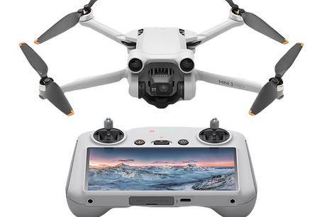
DJI Mavic Mini 3 Pro | 4K HDR Video, Sub-250g weight
Weighing in at just under 250g, the DJI Mini 3 Pro is almost as light as the average smartphone. Capable of capturing 4k HDR video and 48MP RAW photos. The lightweight design places it in the lowest and safest weight class of drones, so it's exempt from certain regulations in the UK and many other countries. This is our go-to Drone for flights in congested and built-up areas.
DJI FPV | Fly through the sky in ways that seem impossible
While most of our clients want smooth cinematic video and high-resolution aerial stills, high-speed, dynamic, and immersive drone footage is becoming increasingly popular. That's why we've invested in the DJI FPV Drone, the world's first fully-fledged, ready-to-fly 4K-equipped FPV racing drone.

DJI Avata | 4K/60fps Video, 155° Supper-Wide FOV, D-Cinelike Colour Mode, Rock Steady 2.0
Compact and lightweight, DJI Avata is nimble in tight spaces. The built-in propeller guard means that if Avata comes in contact with an object, it can bounce back, stay in the air and keep on flying. It's more lightweight, compact, and easy to carry.
