
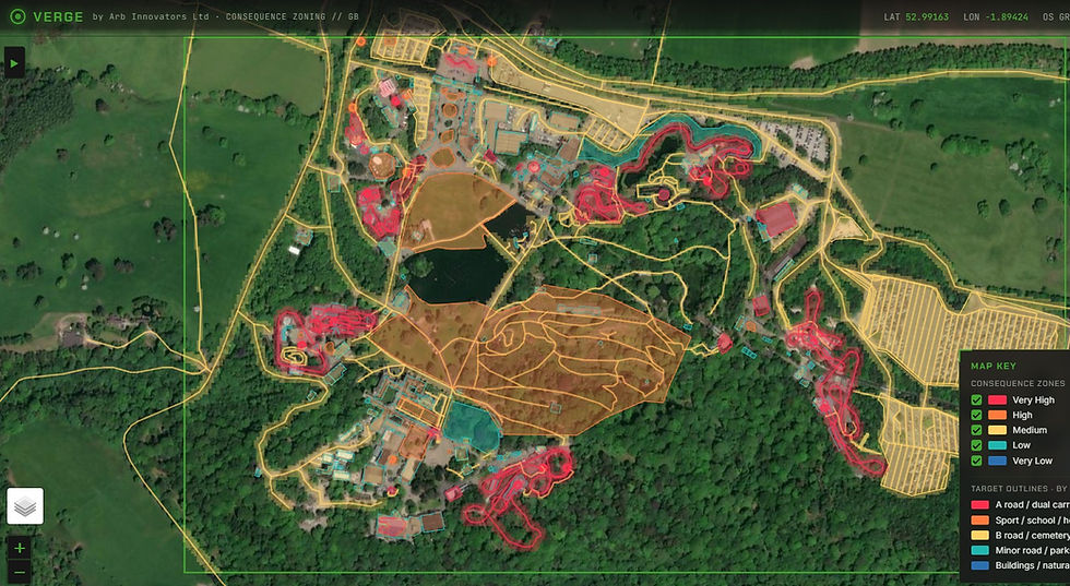
What is tree risk and consequence zoning?
Tree risk and consequence zoning involves dividing your land into areas based on how exposed people and property are, to inform you where tree inspections should occur - typically at the busiest, frequently occupied places more often than the quiet ones.
Most local councils, private estates, and landowners already know they should form risk zones. The hard part is doing it across thousands of trees without a six-figure survey bill and ongoing subscription costs.
Zoning is the first pillar of the National Tree Safety Group's Common Sense Risk Management of Trees, the HSE-endorsed national standard.
That's the gap our tool, closes.


The problem: duty of care meets a finite budget
You're the duty holder for thousands of trees.
You can survey a fraction of them each year.
And when a tree fails, the first question is usually: "was it on the list?"
Prioritising by gut feel, by a residents complaint, or by whatever got surveyed last isn't a strategy. It's exposure.
Your duty of care doesn't extent to inspecting every tree, the HSE has called that "grossly disproportionate."
It asks you to be proportionate and reduce risk as low as reasonably practicable (ALARP). To do that, you need consequence-led tree risk zoning.
How VERGE by Arb Innovators works: consequence in, priorities out
VERGE by Arb Innovators provides a desk-based consequence map of your tree stock.
For every tree located it asks one question: "if this tree failed, what's underneath it?"
A tree over a primary-school playground is not the same as a tree in the middle of a field, even if they're similar trees. VERGE by Arb Innovators makes that difference visible across your whole area and turns it into a clear re-inspection priority
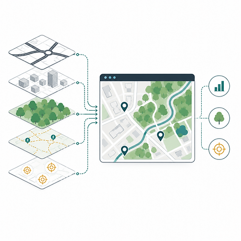
Built with open data
VERGE by Arb Innovators uses the best available open source data for your land to fill in the blanks in the absence of ground surveys and your own tree data.
This includes official open datasets such as National Forestry Inventory, Trees Outside Woodland, highways, footfall proxies, traffic flows and nearby targets.
The method is transparent and repeatable, but it is not limited to generic open data where better client data exists.
Use tree data you already have
Utilising VERGE by Arb Innovators doesn't mean you need to commission a new tree survey. If you already hold tree survey data, whether that is an export from TreePlotter, Ezytreev, Confirm, Pear, Arbortrack, or another tree management system, we can use it.
This means that VERGE can prioritise the trees you already know about, using your existing tree IDs, locations, attributes and inspection history, where available.
We then add the consequence layer around them: roads, footpaths, schools, play areas, buildings, transport corridors and other targets that affect how frequently each tree should be inspected.
Where existing data is incomplete, we can supplement it with open datasets. Where your data is already strong, we do not replace it, we build on it.

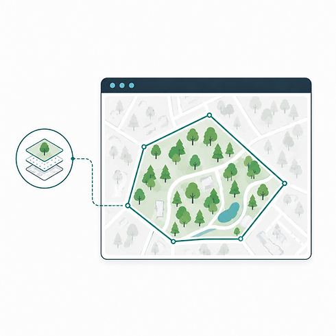
Filter by ownership, responsibility or area of interest
VERGE by Arb Innovators can work with ownership boundaries, land parcels, highway extents, estate boundaries or other areas of responsibility supplied by the client.
We use those boundaries to filter the analysis so the results focus only on trees, zones and heatmap areas that are actually under your control.
That means your inspection priorities are not distorted by neighbouring land, private trees, unmanaged third-party areas or sites outside the scope of your duty. The result is a cleaner, more defensible output: a risk zoning map and inspection schedule limited to the land, trees and areas that matter to you.
Custom scoring
Every organisation manages tree risk differently. VERGE by Arb Innovators allows target scoring and weighting to be adjusted around your own policy, priorities and risk approach.
Roads, schools, railways, buildings, bus stops, play areas, power lines and other targets can be weighted to reflect what matters most to your organisation.

VERGE is consequence-led
Consequence zoning — not a tree risk assessment. It tells you where to direct survey effort. It does not assess the condition, species or likelihood of failure of any individual tree, that's the job of your arborist on the ground.
And that's deliberate.
It complements your existing tree risk assessment, management strategies and your QTRA, VALID or Professional Tree Inspections; it doesn't replace the arborist.

What you receive
A deliverable that's yours to keep. No recurring cost, no access that can be switched off. No software to install. No per-seat fees. No data leaving your control. Opens in any browser, on or offline.
-
An interactive tree risk zoning map of your area, your trees (where provided), consequence zones, prioritised trees, and the reasoning behind each decision.
-
A printable summary report (PDF) with the methodology, zone breakdown, full tree schedule and a competent-person sign-off ready for committee, audit or insurer.
-
Exportable data — the priority schedule as CSV and the zones as GeoJSON. Drops straight into your own GIS or asset system.
-
Client only html viewer - a locked viewer, a read-only HTML file from Arb Innovators VERGE tool itself, showing the tree data alongside the heatmap, priority ratings, schedule, and pre-scored trees.
Who is VERGE tree risk zoning for?
Trees are a fundamental component of our landscape and natural environment but they require proper consideration and tree risk zoning should be the basis of all good tree risk policies.
-
Local authorities & councils: justify your inspection programme to members, auditors and insurers with an estate-wide, NTSG-aligned, consequence-led plan.
-
Landowners & estates: direct limited survey budget where the stakes are highest and evidence your duty of care.
-
Housing associations, universities, NHS trusts, highways teams, and anyone managing a large tree population against a finite budget.

Why VERGE beats a portal subscription
Other providers sell you a login. A proprietary GIS portal, a per-seat licence, an annual bill, and your data living on someone else's platform. Stop paying and it disappears.
We provide you with the deliverable. Built on open government data, it runs in your browser, it's yours to keep, and it costs a fraction of the enterprise-portal route because we're not passing on enterprise-portal licensing.
Same outcome. A defensible, NTSG-aligned, zoned consequence plan. None of the lock-in.
Tree Survey Questions?
We've got it covered.
We're sure you've got a lot of questions and we're more than happy to answer them. When it comes to arboriculture and understanding trees, tree surveying and the various tree surveys and reports available, we're happy to provide the answers. After all, knowledge is power.